❌

Normal view

  • βœ‡Geoff Gibson
  • The Ice-Scraped Goliath and the Frozen Ocean
    The Black River in Canada. Photo by Trick17 - Own work, CC BY-SA 4.0, https://commons.wikimedia.org/w/index.php?curid=46685780I love Canada. It’s home to some of my very favorite cities in the world (especially Vancouver which I try to get up to every year or so). The Canadian Rockies are also so incredibly beautiful it’s almost insulting to the the United States’ Rockies. And each province really feels like it has its own unique culture within Canada, yes even the prairie pro
     

The Ice-Scraped Goliath and the Frozen Ocean

25 March 2026 at 12:01
The Black River in Canada. Photo by Trick17 - Own work, CC BY-SA 4.0, https://commons.wikimedia.org/w/index.php?curid=46685780

I love Canada. It’s home to some of my very favorite cities in the world (especially Vancouver which I try to get up to every year or so). The Canadian Rockies are also so incredibly beautiful it’s almost insulting to the the United States’ Rockies. And each province really feels like it has its own unique culture within Canada, yes even the prairie provinces.

Subscribe now

But here’s the open secret about Canada that you probably already know. Despite how amazing it is, most of it is incredibly hostile to humans. I mean, if you want to understand why 90% of Canadians live within 100 miles of the US border, you don’t need to look at politics or history. You need to look at geography. Specifically, you need to look at the greatest, most dominant geographic tag team on the continent: The Canadian Shield and Hudson Bay. Together, this ancient rock formation and massive inland sea dictate everything about Canada, where people live, how they make money, and the very climate they endure.

Let’s break down how this duo rules the Great White North. And we’ll use a fun wrestling analogy to guide us through it. Because why not?

Oh and if you want to know more about the Hudson Bay specifically, do be sure to check out this week’s video. It was a FUN one!

In one corner: the Canadian Shield (The Heavyweight)

It’s the red part.

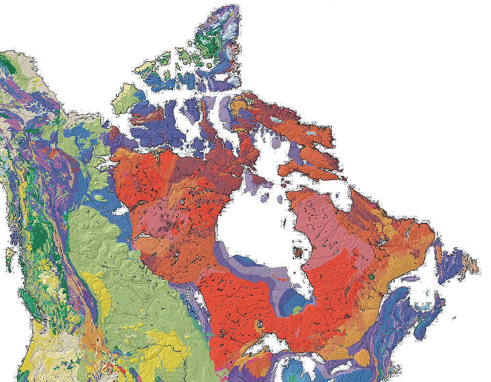
The Canadian Shield is a massive, horseshoe-shaped slab of exposed Precambrian rock covering over half of the country. It’s geologic. It’s buried underneath a loose topsoil of mostly gravel. And it’s some of the oldest rock on the planet, dating back billions of years. You’d be hard pressed to find an older pile of rocks anywhere on the planet.

During the last ice age (because doesn’t it always begin with the last ice age?), massive glaciers miles thick acted like continental bulldozers, scraping away almost all the topsoil and pushing it south into the United States (you’re welcome, Midwest and breadbasket states). When the ice retreated, it left behind a battered, scoured landscape.

This sets up the first pummeling of Canada’s geography by the geographic heavy weight that is the Canadian Shield.

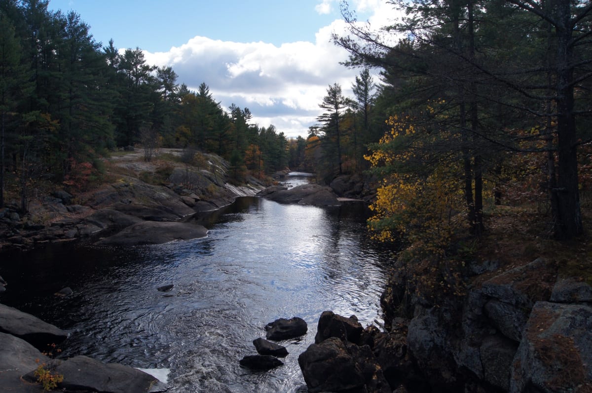
Unfortunately for Canada, because the glaciers scraped away the soil, you simply can’t farm on the vast majority of the Shield. It’s a land of exposed granite, dense boreal forests, bogs (muskeg), and literally millions of lakes. Historically, the rugged terrain of the Shield made building roads and railways an absolute nightmare, effectively splitting eastern and western Canada into two distinct geographic islands.

Now all that said, it’s not all bad for Canada. What it lacks in soil, it more than makes up for in heavy metals. The Shield is packed with gold, nickel, copper, uranium, and diamonds. It makes Canada a mining superpower, but mining towns are remote and sparsely populated.

So Canada takes a bit of a geographic beating from the Canadian Shield, but it also gets a few hits back in the way of mines. In a one-on-one fight, I’d put my money on Canada overcoming the Canadian Shield. Unfortunately, there’s another geographic wrestler in the mix as well.

In the other corner: the Hudson Bay (The Ice-Cold Partner)

Don’t let its mild demeanor fool you…

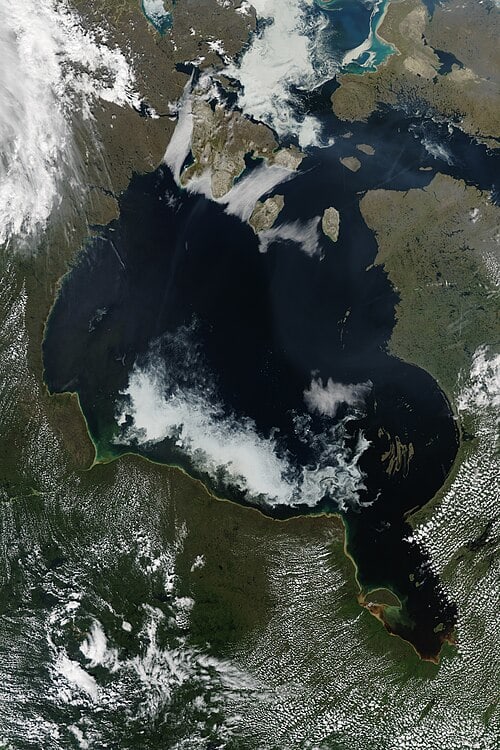
Sitting right in the middle of the Canadian Shield’s giant U-shape is the Hudson Bay. It is the second-largest bay in the world, a massive inland sea that was essentially formed by the sheer weight of the Ice Age glaciers pressing down on the continent’s crust.

If the Shield is the physical barrier, Hudson Bay is the atmospheric enforcer.

You see, the Hudson Bay is relatively shallow, which means it freezes over completely during the winter and takes a long time to thaw. This massive block of ice acts like an open refrigerator door in the middle of the country, dragging Arctic air violently south.

Because of the Hudson Bay, places in Canada are significantly colder than locations at the exact same latitude in Europe. Edinburgh, Scotland, and Churchill, Manitoba are roughly at the same latitude. Edinburgh rarely sees snow; Churchill has polar bears walking down the street.

The finisher move

Individually, both of these geographic entities are formidable. Any country whatsoever would struggle with them, despite any economic benefits they might also bring. But together, they are an unbeatable geographic force.

The Hudson Bay freezes the heart of the country, while the Canadian Shield ensures that even if it were warmer, you still couldn’t grow crops there. This tag team effectively renders over half of the second-largest country on Earth largely uninhabitable for mass settlement.

They execute a perfect “southward squeeze,” forcing the Canadian population into the few hospitable pockets left available: the Great Lakes-St. Lawrence Lowlands, the Prairies, and the West Coast.

What’s most fun here though is that often think of countries being shaped by treaties, wars, or visionary leaders. And Canada certainly has had plenty of those. But also Canada was (and still is if we’re being honest) shaped by an ancient rock formation and humongous, freezing bowl of water. The Canadian Shield and the Hudson Bay don’t just dominate the map, they define so much of the Canadian identity: rugged, resource-rich, and clustered together against the cold.

Fascinating!

Share

  • βœ‡Geoff Gibson
  • Africa’s Great Lakes defy everything we know about North America’s
    We often think of “The Great Lakes” as a single place in the middle of North America, straddling the border between Canada and the United States. In fact, even at the very mention, you’re probably already picturing the sprawling, sometimes-frigid expanses of Lakes Superior, Huron, Michigan, Erie, and Ontario. They are an undeniable geographic boon, holding about 21% of the world’s surface fresh water.Subscribe nowBut look across the globe to the heart of the African cont
     

Africa’s Great Lakes defy everything we know about North America’s

1 April 2026 at 12:04

We often think of “The Great Lakes” as a single place in the middle of North America, straddling the border between Canada and the United States. In fact, even at the very mention, you’re probably already picturing the sprawling, sometimes-frigid expanses of Lakes Superior, Huron, Michigan, Erie, and Ontario. They are an undeniable geographic boon, holding about 21% of the world’s surface fresh water.

Subscribe now

But look across the globe to the heart of the African continent, and you’ll find another collection of massive inland seas: The Great Lakes of Africa (aka The African Great Lakes).

Anchored by the massive Lake Victoria, this network (which also includes Tanganyika, Malawi, Albert, Edward, Kivu, and Turkana) is a completely different geographic behemoth. While they share a name with their North American cousins, the forces that created them, the depths they reach, and the life they sustain couldn’t be more different.

And of course if you’re interested in just one small part of these Great Lakes, be sure to check out my video for the week:

Ice vs. tectonics

a sailboat with two people on it in the water
Lake Victoria. Photo by Evans Dims on Unsplash

The most fundamental difference between the two Great Lake systems is how they were born and the age that are.

Let’s get this out of the way first: the North American Great Lakes are geologic toddlers, born of the last ice age. Roughly 10,000 to 14,000 years ago, as the last Ice Age came to a close, the massive Laurentide Ice Sheet retreated. As this miles-thick glacier scraped across the continent, it gouged deep basins into the earth’s crust. When the ice melted, it filled these basins with fresh water. They are essentially giant, glorious glacial puddles. And what’s crazier is that this all happened while humans roamed the earth. So, in theory, we as a species has known the world before the Great Lakes of North America, and now the world after.

Meanwhile the African Great Lakes are ancient, born of literal earth-shattering tectonic forces. Instead of being carved from above by ice, the African Great Lakes were torn open from below. They lie along the East African Rift, an active continental rift zone where the African tectonic plate is literally splitting in two. As the earth’s crust pulls apart, massive valleys drop down, creating incredibly deep chasms that have filled with water over millions of years.

Now, of course, there is one exception here: Lake Victoria. While lakes like Tanganyika and Malawi are classic “rift lakes”—long, narrow, and plunging deep into the earth’s crust—Lake Victoria is the odd one out. It is the largest lake in Africa by surface area, but it doesn’t sit in a deep rift trench. Instead, it occupies a shallow, saucer-like depression created by the uplifting of the rifts on either side of it. So still connected, but it’s not technically a rift lake.

Now, because of their violent, tectonic origins, the rift lakes of Africa boast statistics that make the North American lakes look like wading pools.

  • Depth: Lake Tanganyika is the second-deepest lake in the world (behind Russia’s Lake Baikal), plunging to a incredible depth of 4,820 feet (1,470 meters). To put that in perspective, Lake Superior, the deepest of the North American Great Lakes, reaches a maximum depth of 1,332 feet.

  • Volume: Because they are so incredibly deep, the African Great Lakes hold a staggering amount of water. Lake Tanganyika alone holds nearly as much water as all five North American Great Lakes combined.

  • Age: While the North American lakes are around 10,000 years old, Lake Tanganyika is estimated to be between 9 and 12 million years old. Lake Malawi is roughly 1 to 2 million years old. So even their “baby” Great Lake is at least a million years older than North America’s.

The evolutionary mixing pot of the world

two white sailboats on sea
Lake Michigan. Photo by Chris Pagan on Unsplash

But here’s the biggest difference between the two.

Because of the immense age and isolation of the African Great Lakes have turned them into some of the most spectacular evolutionary laboratories on the planet, rivaling even the Galapagos Islands.

And because the North American lakes are so young and experienced extreme glacial freezing, they have relatively low levels of what we call “endemism” (or species that are found nowhere else on earth). Most of their fish migrated there from other river systems after the ice melted.

The African Great Lakes, however, have been stable, tropical underwater worlds for millions of years. This allowed a specific family of fish (such as cichlids) to undergo something biologists call adaptive radiation. From just a few ancestral species, thousands of unique, vibrantly colored species evolved, each adapting to highly specific micro-regions within the lakes.

In fact, Lake Malawi alone is home to an estimated 850 to 1,000 distinct species of cichlids. And Lake Victoria, despite a recent near-collapse due to the introduction of the invasive Nile Perch, once housed over 500 endemic cichlid species.

In these lakes, you’ll find fish that have evolved to eat only the scales of other fish, fish that crush snail shells, and fish that incubate their eggs safely inside their own mouths. It is an explosion of biodiversity that simply does not exist in the glacially carved basins of North America.

Both are masterpieces in their own right

To compare the North American and African Great Lakes isn’t to say one is better than the other. Rather, it highlights the incredible, diverse geography of our planet.

In North America, we see the lingering footprint of an ice age that recently shaped our modern landscape. In Africa, we are looking into deep time—staring down into the literal seams of the earth where tectonic plates rip apart, fostering millions of years of uninterrupted and brilliant evolution.

Both systems are “Great.” But they achieved their greatness through entirely different paths.

Share

❌